India and Her Neighbours Class 7 Question Answer SST Part 2 Chapter 2
India and Her Neighbours Class 7 Questions and Answers
Class 7 SST Part 2 Chapter 2 Question Answer
The Big Questions (Page 29)
Question 1.
What defines a ‘neighbour’? Is it just shared land borders?
Answer:
Traditionally, a neighbour is thought of as a country that shares a land boundary. A mar¬itime neighbour is a country connected by a shared sea or ocean, even without a direct land border. Countries like Iran, Oman, Thailand, Malaysia, Singapore, and Indonesia are part of India’s maritime neighbourhood. So, it is not just about shared land borders; the ocean acts as a vital link for trade and historical ties.
Question 2.
How do geography and history influence the nature of India’s relationships with her neighbours?
Answer:
Geography and history together play a decisive role in shaping India’s relations with its neighbours. Mountains, rivers, and seas connect India with neighbours. Trade routes existed since ancient times. Religions like Buddhism and Hinduism spread across borders. Historical empires and migrations created strong ties. Geography and history shape cooperation and challenges. Thus, India’s neighbourhood relations are a blend of friendship and rivalry, shaped by geography that binds nations together and history that both unites and divides them.
Class 7 Social Science Part 2 Chapter 2 Question Answer
Question 3.
In what ways are India and her neighbours interconnected today?
Answer:
Today, India and her neighbours are interconnected through trade, culture, travel and business by transport routes and tourism, Through shared culture, festivals, and languages. By cooperation in disaster relief and development projects. Through regional organisations like SAARC.
Don't Miss Out (Page 30)
Question 1.
Who is a maritime neighbour?
Answer:
A maritime neighbour is a country connected to another by a shared sea or ocean, even without a direct land border.
Let’s Explore
Question 1.
Identify the three large water bodies that surround India in the map on the (Page 30)
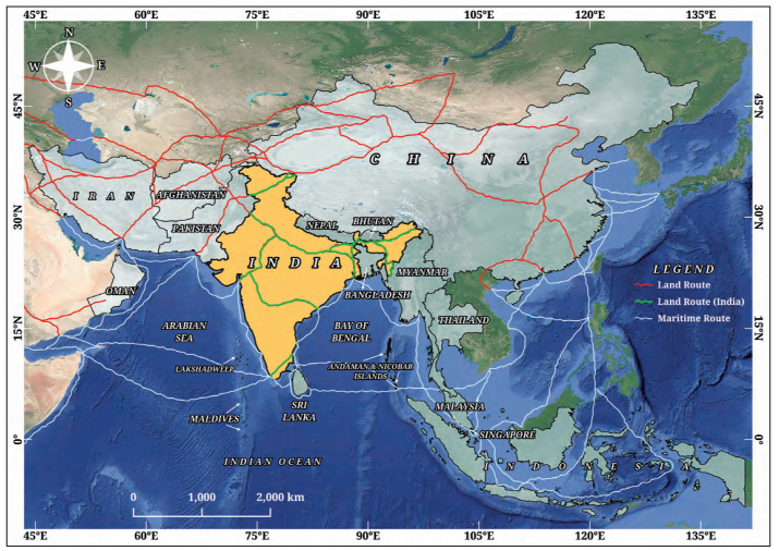
Fig. 2.2. A simplifid map of the major land and sea routes that have connected India with many regions and countries of Eurasia and Africa over the centuries. (The routes shown here are approximate and flctuated in time.)
Answer:
The three large water bodies that surround the Indian subcontinent are:
- The Arabian Sea to the west.
- The Bay of Bengal to the east.
- The Indian Ocean to the south.
Question 2.
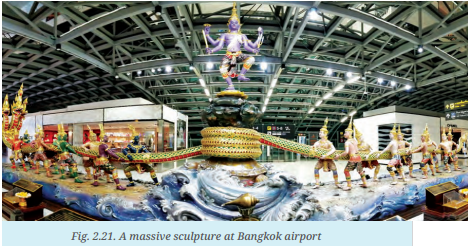
The scene in Fig. 2.21 depicts the well-known Hindu myth of samudra manthana or the churning of the ocean. The devas (gods, on the right here) and the asuras (demons, on the left) decided to join forces to churn the cosmic ocean in search of amrita or the nectar of immortality, with the serpent Vasuki as the churning rope and Vishnu (above) presiding over the operation — he will eventually deceive the asuras to make sure that the amrita goes to the devas alone. Note also the airport’s official name of ‘Suvarnabhumi Airport’ — does it remind you of something? (Page 51)
Answer:
Yes, the official name of ‘Suvarnabhumi Airport’ reminds us the islands of Java, Sumatra and Malaya, Indian traders visited these islands in search of gold and other valuable resources that these places to came to be known as “Suvarnabhumi” (the golden land) or “Suvarnadvipa” (the golden island).
Question 3.
Seeing that Tamil is one of Singapore’s official languages, what does this suggest to you about the relationship between south India and Singapore? (Page 53)
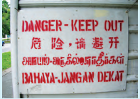
Fig. 2.23. A signage in Singapore’s four offial languages — English, Mandarin, Tamil and Malay.
Answer:
Tamil is one of Singapore’s official languages. It shows the strong relationship between South India and Singapore.
Singapore shares close cultural and commercial ties with India.
Buddhist monks and traders visited Singapore a few centuries BCE.
Don’t Miss Out
Question 1.
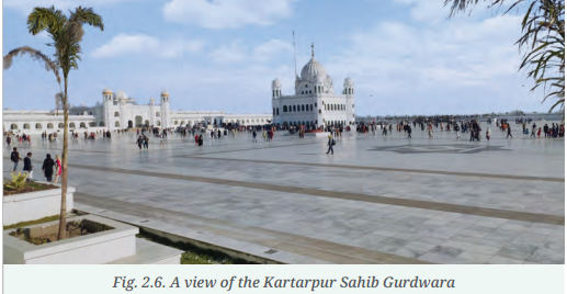
Can the Cartarpur Corridor be a model for the possible progress of peace and dialogue? (Page 36)
Answer:
Yes, the Kartarpur corridor can be seen as a small but meaningful"step toward peace be¬tween India and Pakistan. By allowing Indian Sikh pilgrims to visit a holy site in Pakistan without visas, it shows how shared faith and culture can overcome political barriers. Though larger issues still divide the two nations, the corridor highlights that cooperation in areas of mutual respect can build trust and open the door for dialogue.
Class 7 India and Her Neighbours Question Answer
Questions and Activities (Page 60)
Question 1.
Explain who a maritime neighbour is with two examples with respect to India.
Answer:
A maritime neighbour is a country across the sea. It shares sea boundaries with another country. Sea routes connect these countries. Sri Lanka is India’s closest maritime neighbour. Thailand is another maritime neighbour of India connected through Trilateral highway which stretches from Manipur through Myanmar to Thailand.
Question 2.
How has Buddhism created links with India’s neighbours? Give examples to explain your answer.
Answer:
Buddhism originated in India and created strong cultural and spiritual links between India and her neighbours. It spread to Sri Lanka, Nepal, Bhutan, and Myanmar. Buddhist monks travelled to Nepal, Bhutan, Sri Lanka, China and Myanmar and shared teachings. Ancient stupas and monasteries exist in these countries. These exchanges built bonds of faith, learning and culture, showing how Buddhism acted as a bridge linking India with its neighbours across history.
Question 3.
What does ‘open border’ policy mean? How does the India-Nepal ‘open border’ policy affect the lives of people living along the border?
Answer:
Open border means free movement without visas. India and Nepal share an open border. People can work, live, and trade freely. Families and cultures remain closely connected. It strengthens friendship and cooperation. The people from both sides create such type of bonding that they make marriage relations too. However, this policy has increased vulnerability to illegal activities. India and Nepal’s government work together to ensure the open border remains safe and take actions in misusers or on illegal activities.
Question 4.
The chapter says, “Being neighbours is not just about geography.” Explain this statement with an example.
Answer:
“Being neighbour is not just about geography”. It is more about culture, history, and values. It is far beyond the geographical landscape and border. India and Sri Lanka share religious and cultural ties.Buddhism connects both countries. India has still good trade relations with China. So, neighbours are connected beyond physical borders.
Question 5.
What are the different ways in which India has helped smaller countries in her neighbourhood? Explain with examples.
Answer:
India helps its smaller neighbors through its “Neighbourhood First Policy” via development aid, disaster relief, connectivity projects (roads, energy), security cooperation, and cultural/educational ties, acting as a first responder in crises and providing economic lifelines.
- Nepal: Rapid response to 2015 earthquake, LoCs for development, hydropower projects.
- Sri Lanka: Economic assistance during its 2022 crisis, financial support.
- Maldives: Maritime security, infrastructure (Greater Male Bridge), financial stability support.
- Bangladesh: Energy cooperation (power trade), connectivity projects, joint border patrols.
Question 6.
How do shared challenges become opportunities for cooperation? Were there examples in this chapter to illustrate this?
Answer:
Shared challenges become opportunities for cooperation when they create a “superordinate goal”—an objective that is urgent, affects all parties equally, and cannot be resolved by any single group acting alone. These obstacles compel actors to move beyond competition, share resources, pool expertise, and build mutual trust, transforming a shared problem into a collaborative opportunity.
Examples:
- Disputes and conflicts regarding shared borders and heightened tensions between India and China are being resolved through trade, dialogue and border resolution mechanisms.
- Kartarpur corridor in Pakistan is a great opportunity for thousands of Sikh pilgrims to visit the Gurudwara Darbar Sahib in Pakistan.
- Sundarbans National Park’s, it’s protection and management has coordinated India and Bangladesh relations.
- The land border agreement (2018) between India and Myanmar facilitate the cross border movement for people living in border areas.
- India and Indonesia: Strategic cooperation has grown stronger, particularly in maritime security, defence and disaster relief. Both countries share common concerns about piracy, climate change and the protection of sea lanes.
Question 7.
If borders were drawn only by culture and connections, how would the map look different?
Answer:
If world borders were drawn exclusively based on culture, language, and social connections rather than historical treaties and colonial lines, the map would appear less as a set of rigid straight lines and more as a complex, “patchwork” mosaic of smaller, ethno-linguistic, or regional states.
- This type of map would represent shared identities, languages, religions, culture and historical connections rather than administrative and legal divisions.
- In reality constructing this type of map would be really a complex and complicated process. In my opinion, it would create conflicts and confusion too.
Question 8.
On blank maps:
Answer:
(a) Label India’s neighbours.
India shares land and maritime borders with nine countries.
- Land Borders: Pakistan, Afghanistan, China, Nepal, Bhutan, Bangladesh and Myanmar.
- Maritime Borders: Sri Lanka and the Maldives.
(b) Draw arrows showing cultural flows (e.g., food, festivals, languages) between India and her neighbours.
Answer:
Use different colored arrows on your map to illustrate various cultural exchanges. Examples of Cultural Flows:
Food:
- India ↔ Pakistan ↔ Bangladesh: Shared culinary bases in curries, flatbreads (naan, roti), and
- sweets.
- India ↔ Nepal: Similarities in momos (dumplings), dal bhat (lentil soup and rice).
- India ↔ Southeast Asia (Myanmar): Influence of spices, rice dishes; shared love for tea.
Festivals:
- India ↔ Nepal: Common celebration of Diwali/Tihar, Holi, and Dashain (Dussehra).
- India ↔ Pakistan ↔ Bangladesh: Eid-ul- Fitr and Eid-ul-Adha are major festivals.
- India ↔ Sri Lanka: Shared Buddhist and Hindu festivals like Vesak Poya and Pongal.
Languages:
- Hindi/Urdu belt: Mutual intelligibility across Northern India and much of Pakistan and Bangladesh.
- Bengali: Spoken widely in West Bengal (India) and throughout Bangladesh.
- Tamil: Shared heritage in South India and Sri Lanka.
- Indo-Aryan languages: Form a large family across all these northern neighbors.
(c) Imagine and redraw new “borders of friendship” that connect neighbours through rivers, trade routes, or cultural zones.
Answer:
This is an imaginative exercise designed to promote a sense of regional unity. On a separate, new map (or an overlay), draw “friendly’ borders that link nations based on shared features. Suggestions for New Borders:
- River Basins: Draw a new “Ganges-Brahmaputra Friendship Zone” that encompasses the areas of Nepal, Northern India, and Bangladesh linked by these major rivers.
- Historical Trade Routes: Trace the ancient Silk Road routes linking Northern India, Pakistan, and China.
- Cultural/Linguistic Zones: Outline a single border for a “Dravidian Cultural Zone” connecting South India and Sri Lanka, or a “Himalayan Buddhist Belt” linking northern India, Nepal, Bhutan, and China’s Tibetan autonomous region.
(d) Collect pictures of the flags of the countries listed in this chapter and write your observations.
Answer:
Collect physical images or printouts of the flags for India, Pakistan, China, Nepal, Bhutan, Bangladesh, Myanmar, Sri Lanka, and Maldives.
Observations to Note:
Exploring Society India and Beyond Class 7 Solutions
More from Class 7
- Banks and the Magic of Finance Class 7 Extra Questions and Answers SST Part 2 Chapter 8
- Infrastructure: Engine of India’s Development Class 7 Extra Questions and Answers SST Part 2 Chapter 7
- The State, the Government, and You Class 7 Extra Questions and Answers SST Part 2 Chapter 6
- India, a Home to Many Class 7 Extra Questions and Answers SST Part 2 Chapter 5
- Turning Tides: 11th and 12th Centuries Class 7 Extra Questions and Answers SST Part 2 Chapter 4
- Empires and Kingdoms: 6th to 10th Centuries Class 7 Extra Questions and Answers SST Part 2 Chapter 3
More in Social Science
- Banks and the Magic of Finance Class 7 Extra Questions and Answers SST Part 2 Chapter 8
- Infrastructure: Engine of India’s Development Class 7 Extra Questions and Answers SST Part 2 Chapter 7
- The State, the Government, and You Class 7 Extra Questions and Answers SST Part 2 Chapter 6
- India, a Home to Many Class 7 Extra Questions and Answers SST Part 2 Chapter 5
- Turning Tides: 11th and 12th Centuries Class 7 Extra Questions and Answers SST Part 2 Chapter 4
- Empires and Kingdoms: 6th to 10th Centuries Class 7 Extra Questions and Answers SST Part 2 Chapter 3