Geographical Diversity of India Class 7 Question Answer Social Science SST Chapter 1
Class 7 SST Chapter 1 Geographical Diversity of India Question Answer
Geographical Diversity of India Class 7 Questions and Answers
The Big Questions (Page 1)
Question 1.
What are some key geographical features of India?
Answer:
Some geographical features of India are the following:
The Mighty Himalayas:
- It is located in the North, covered with snow, a source of river water.
- It behaves like a barrier and stops the cold wind.
The Desert:
- Areas having harsh conditions.
- Areas having rugged terrain, deep valleys, very little rainfall.
The Gangetic Plains:
- The plains where India’s civilization developed.
- Ideal for agriculture, and good for transportation networks.
The Peninsular Plateau:
- Covered all three sides by water.
- Bordered by 2 mountain ranges, the Western Ghats and Eastern Ghats.
- Vital for India’s economy because of its richness in minerals, forests, and fertile land.
The Coastlines:
- Adorned with the west coast and east coast.
- Have beautiful beaches, rocky cliffs and lush green forests.
Indian Islands:
- Majorly 2 islands:
- Lakshadweep Islands (36 Islands made of corals)
- Andaman and Nicobar Islands (500 large and volcanic Islands).
The Delta:
- This is triangular in shape.
- Examples: Sundarbans are home to many species, including Royal Bengal Tiger.
The hills of the Northeast:
- Hills are part of the Meghalaya plateau.
- Full of greenery, an area known for the highest rainfall in the world, breathtaking waterfalls.
Question 2.
How does India’s geographical diversity affect our lives?
Answer:
India’s geographical diversity affects our lives in the following ways:
By the way of its topography:
- India’s topography refers to the areas that are suitable for living or not.
For Example:
- In snow-covered areas, growth in life is almost either difficult or very little life there.
- On the other hand, the plains are rich in flora and fauna i.e. life grows and develops in these areas at a good pace.
By the way of its climate:
- India’s climate also determines the life of the particular areas.
For Examples:
- If the climate of a particular area is suitable for survival, such areas are abundant.
- On the other hand, if the climate is harsh in any other area, there might be no life or very little life there.
By the availability of water resources (Rivers):
- The availability of water is the feature that determines the extent of life.
For example:
- The possibility of water is very low in the area i.e. no life is existed in such places.
- On the other hand the area has sufficient water and water resources, good for various economic activities.
- That’s why life in such places grows in large volume.
By the way of Rivers Plains:
- Historically, river plains were good for developing civilization, but they are significant now.
- These regions are genuinely rich in fertile land because of every useful mineral in the soil.
- The regions are good for transportation networks.
- That’s why a large proportion of lives are seen in these areas.
Class 7 Social Science Chapter 1 Geographical Diversity of India Question Answer
LET’S EXPLORE (Page 2)
Question 1.
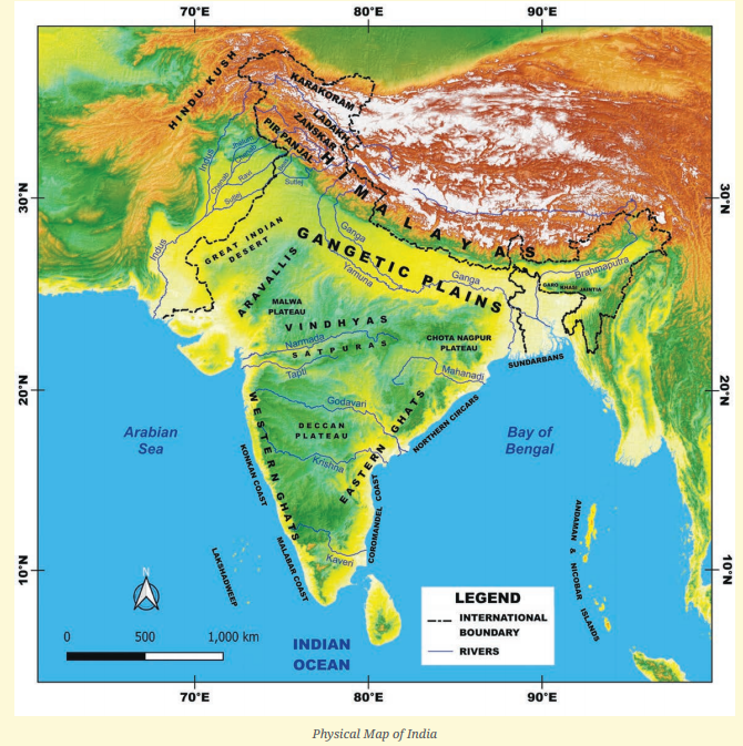
Look at the map of India at the end of this book. What are you able to observe? Recall your lesson on different types of landforms — mountains, plains and plateaus. Which landforms can you identify on the map? What do the different colours on the map mean? (Hint: The legend of the map shows the height of each area.)
Answer:
Looking at the map of India at the end of this book, we are able to observe that India has a variety of landforms.
We can identify the following types of landforms for the map:
- The Himalayan mountain range in the north.
- The Gangetic Plains
- The peninsular plateau
- The Great Indian Desert
- The drainage system of various rivers
- India’s coastlines
The different colours on the map mean- “The altitude of the lands”
LET’S EXPLORE (Page 3)
Question 1.
Do you recall your lesson on latitudes and longitudes? Look at the map. Can you read, approximately, the latitude and longitude where India lies?
Answer:
Yes, I do.
Latitudes:
- These are imaginary lines, which run horizontally from east to west.
- These help to determine the distances of places from the equator.
Longitudes:
- These are imaginary lines that run vertically from the North Pole to the South Pole.
- These have to determine the distance of East and West from the prime meridian.
- Looking at the maps. Yes, I can read approximately where India lies. India lies at the following latitudes and longitudes:
- Latitudes: 8°4’ to 37°6’ N
- Longitude: 68°7’ to 97°25’ E
Question 2.
Identify the above features on India’s physical map.
Answer:
Do yourself
LET’S EXPLORE (Page 6)
Question 1.
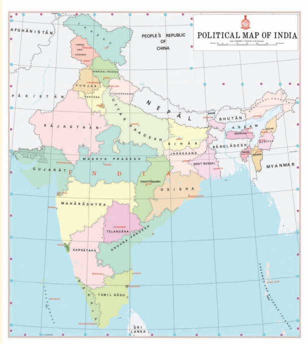
Can you please locate the names of the states in the different parts of the Himalayas?
Take the help of both the physical and political maps for this exercise.
Answer:
Yes, I can.
With the help of physical and political maps,
In Western Himalayas:
- Jammu and Kashmir
- Himachal Pradesh
- Punjab
In Central Himalayas:
- Uttrakhand
In the Eastern Himalayas:
- Arunachal Pradesh
- West Bengal
- Sikkim
LET’S EXPLORE (Page 11)
Question 1.
Notice the concentration of lighting in the Plains. What could be the reason for this concentration?
Answer:
There could be some main reasons for the concentration of lighting in the plains which are given below:
1. Topographical Reason:
For example: the altitude of the plains.
2. Climatic region:
For example: abundance of moisture, moment of convection currents etc.
LET’S EXPLORE (Page 12)
Question 1.
What is the shape of a sand dune? While mountains are made of rock and their shape is fixed, why do you think sand dunes have a similar shape, even though they are made of sand? (Page 12)
Answer:
The shape of a sand dune is hill-like.
The statement is absolutely correct, “While mountains are made of rock and their shape is fixed”.
On the other hand, Sand dunes are made of sand and have a similar shape because :
1. Movement of steady winds and its shifting:
- Windward movement of winds
- Leeward movement of winds
2. Gravity :
- That determines the pointed shapes, sharp slopes etc.
LET’S EXPLORE (Page 14)
Question 1.
Let’s go back to the map. Trace your path slowly from the Thar Desert towards the east. Do you see the Aravali hills? (Page 14)
Answer:
On moving from the Thar Desert towards the East, I found a noticeable change from the Sandy region to the Rocky region.
Yes, of course, I see the Aravalli Hills. The Aravallis are among the oldest mountains in the world.
LET’S EXPLORE (Page 15)
Question 1.
Look at the political map in the textbook and identify the states that the range spans. Did you see Delhi, Rajasthan, Haryana and Gujarat?
Answer:
Yes, I see Delhi, Rajasthan, Haryana and Gujarat on looking at the political map in the textbook.
No doubt, all these states are part of the Aravalli Hills.
LET’S EXPLORE (Page 16)
Question 1.
Look at the physical map of India given at the end of the book. Notice the direction of the flow of the rivers. (Page 16)
Answer:
The directions of the flow of the rivers are as follows :
1. North to South :
- The Indus, The Ganga, The Brahmaputra
2. West to East:
- The Kaveri, The Godavari, The Krishna etc.
3. East to west:
- The Narmada and The Tapi
LET’S EXPLORE (Page 17)
Question 1.
Tribal communities are largely spread over the states of Jharkhand, West Bengal, Odisha, Assam, Madhya Pradesh, Chhattisgarh, Maharashtra, Telangana and Gujarat, Examine the physical and political maps at the end of this book to locate the states and connect them to their location on the physical map.
Answer:
Do yourself
LET’S EXPLORE (Page 19)
Question 1.
Look at the physical map of India in your school atlas or Wall map and find the names of five rivers that flow into the Bay of Bengal. Find out India’s coastal states and discuss the difference between the Western and eastern coastal plains.
Answer:
Do yourself.
Differences between the western and eastern coastal plains are as follows:
| The Western Coastal Plains | The Eastern Coastal Plains |
| The Western coastal plain runs along the Arabian Sea. | The eastern coastal plain runs along the Bay of Bengal. |
| States: Gujarat, Maharashtra, Goa, Karnataka, Kerala. | States: West Bengal, Odisha, Andhra Pradesh and Tamil Nadu |
Question 2.
Do you know what it is called when these rivers split into multiple Streams near the coast? Discuss with your teacher in class to find out!
Answer:
Yes, I know.
It is called delta when these rivers split into multiple Streams near the coast.
Discuss with your teacher in class to find out more information about ‘the Delta’. During the discussion following points came to light:
- The Delta is triangular in shape.
- It is formed at the mouth of the river.
- It is very fertile in nature.
Note: Sundarban forests are located in the Delta.
Class 7 Geographical Diversity of India Question Answer
Questions and Activities (Page 24-25)
Question 1.
What, in your opinion, are two important geographical features of India? Why do you think they are important?
Answer:
In my opinion, the two important geographical features of India are as follows:
- The mighty Himalayas and their young folded mountains
- The indo-gangetic plain think they are important because of the following reasons:
Importance of Himalayas:
- The Himalayas act as a natural barrier and protect us from the cold wind coming from the north.
- The Himalayas are a good source of most of the Indian rivers.
- The Himalayas are the beauty of India.
- The Himalayas are important to many cultures and belief systems.
Importance of the Indo-Gangetic plains:
- Plains are the homes of many well-known civilizations.
- Plains allow for the development of transportation networks.
- Plains provide settlement and support a large population with their agricultural activities.
Question 2.
What do you think India might have looked like if the Himalayas did not exist? Write a short note or sketch a drawing to express your imagination.
Answer:
I think India might have looked like a land, which is geographically either cold frozen land or an arid or semi-arid region if the Himalayas did not exist.
We understand it through a short note:
As we know the Himalayas behave like natural barriers and protect us from the cold winds coming from the north. In the absence of the Himalayas, the cold wind moves freely on the land and the land does not exist in the same way as it is today. I mean to say that the cold winds make life more difficult to survive. In simple words, the existence of life becomes difficult. In the absence of the Himalayas, the lifeline like water that makes the indo-gangetic plains fertile and supports the crores of people to survive. They wouldn’t have even existed. In the absence of the Himalayas, the patterns of rainfall and Indian civilization would have been totally absent.
Question 3.
India has been called a ‘mini- continent’. Based on what you’ve read, why do you think this is so?
Answer:
India has been called a ‘mini- continent’ because it has numerous features, which we expect across the continent should have.
We think so because:
- India is larger in size.
- India has a natural boundary in the form of the Himalayas in the north.
- India has a desert-like The Thar Desert.
- India has magnificent plateaus having numerous waterfalls.
- India has numerous rivers.
- India has plains, islands etc.
- India has different types of climates.
- India has diverse cultures.
These above-mentioned points with regard to India give us a feel of a continent.
Question 4.
Follow one of India’s big rivers from where it starts to where it meets the ocean. What are the different ways in which people might utilise this river along its journey? Discuss in groups in your class.
Answer:
Discussed points in groups in my class regarding India’s big river : ‘The Ganga’ are the following:
Originate in: Gangotri glacier in Uttarakhand.
Meets the ocean: The Bay of Bengal.
Flows through the States: Uttar Pradesh, Bihar, Jharkhand and West Bengal.
Utilisation of the Ganga’s water along its journey is the following :
- Utilisation for agricultural activities
- Utilisation for fishing
- Utilisation for transportation
- Utilisation for religious and cultural activities
- Utilisation for tourism.
Question 5.
Why is the southern part of India referred to as a peninsular plateau?
Answer:
The southern part of India is referred to as a peninsular plateau because:
- It is covered from all three sides with water.
- It is raised higher than the surrounding lands.
- It is older than the other parts of the land. In simple words, the old types of rocks are found in this plateau.
Question 6.
Which UNESCO Heritage site mentioned in this chapter did you find more interesting?
Write a short paragraph to describe what about it is interesting.
Answer:
I found a UNESCO Heritage site viz. Sundarbans is more interesting.
A short paragraph describing about Sundarbans as an interesting site:
The location of Sundarbans is itself very interesting, which is in West Bengal. The largest mangrove forests in the world can be seen here. The Sundarbans are home to many species including the Royal Bengal tiger. The most interesting point which I noticed is how, in this challenging environment, the trees grow in the salty water and how such unique animals or plants survive especially in these challenging regions.
Question 7.
Look at the two maps of India, physical as well as political, given at the end of this book. Identify the place you are at now. Which physical features of India would you use to describe its location?
Answer:
Do yourself
Question 8.
Food preservation techniques differ from place to place across India. They are adapted to local conditions. Do a class project. Gather different methods of preserving food. Hint: drying vegetables when they are in season for use during the off-season.
Answer:
Yes, Food preservation techniques indeed differ from place to place. They are adapted to local conditions.
In class project:
For Display:
- Prepare a visual board, showing methods of preserving food.
Demonstration:
- Show some samples like dried fruits and vegetables, pickles and packaged foods etc.
Interactive activities:
- Request your friends or classmates to taste the preserved foods and tell them how you prepared mango pickles of mangoes.
Gathered different methods of preserving food are as follows:
- Using cold storage
- Drying season vegetables and using them in the off-season.
- Making pickles.
- Adding salt and sugars to items.
- Keeping the items in oil for preservation.
Question 9.
Despite having such different regions (mountains, deserts, plains, coasts), India remains one country. How do you think our geography has helped unite ^ people?
Answer:
It is correct that despite having such different regions, India remains one country. I think our geography has helped unite people in the following manners :
- Due to geographical diversity, no region has the same types of fertile plains, similar climates and exactly the same resources. That’s why People would have to exchange their goods with others. This is the first point to keep the people united.
- In the north, the presence of the Himalayas gives us protection from outsider attacks, protects us too from the cold wind coming from the north and provides a safe environment to the people, that’s the second point which keeps the people united.
- The coastal regions, through trade and economy and with sharing the cultures and customs from one place to another place, genuinely help to keep the people united.
Exploring Society India and Beyond Class 7 Solutions
More from Class 7
- Banks and the Magic of Finance Class 7 Extra Questions and Answers SST Part 2 Chapter 8
- Infrastructure: Engine of India’s Development Class 7 Extra Questions and Answers SST Part 2 Chapter 7
- The State, the Government, and You Class 7 Extra Questions and Answers SST Part 2 Chapter 6
- India, a Home to Many Class 7 Extra Questions and Answers SST Part 2 Chapter 5
- Turning Tides: 11th and 12th Centuries Class 7 Extra Questions and Answers SST Part 2 Chapter 4
- Empires and Kingdoms: 6th to 10th Centuries Class 7 Extra Questions and Answers SST Part 2 Chapter 3
More in Social Science
- Banks and the Magic of Finance Class 7 Extra Questions and Answers SST Part 2 Chapter 8
- Infrastructure: Engine of India’s Development Class 7 Extra Questions and Answers SST Part 2 Chapter 7
- The State, the Government, and You Class 7 Extra Questions and Answers SST Part 2 Chapter 6
- India, a Home to Many Class 7 Extra Questions and Answers SST Part 2 Chapter 5
- Turning Tides: 11th and 12th Centuries Class 7 Extra Questions and Answers SST Part 2 Chapter 4
- Empires and Kingdoms: 6th to 10th Centuries Class 7 Extra Questions and Answers SST Part 2 Chapter 3